
Mount Rainier National Park, with 236,381 un-spoiled acres, was established in 1899, 17 years before the National Park Service was formed, making it one of the oldest in the nation. Ascending to 14,410 feet above sea level, Mount Rainier stands as an icon in the Washington landscape. An active volcano, Mount Rainier is the most glaciated peak in the contiguous U.S.A., spawning six major rivers. It is the most prominent peak in the Cascade Range. Mount Rainier last erupted approximately 150 years ago. Coniferous trees dominate and the lower slopes have dense forests of giant Douglas firs, western red cedars, and mountain hemlocks. During the warm months the alpine meadows are covered with wildflowers that bloom progressively higher up the slopes as the summer passes. The park’s wildlife is abundant and varied and includes deer, Roosevelt elk, bears and mountain goats and there are also more than 140 bird species. One of the park’s most scenic drives runs from the Nisqually entrance to Paradise. This 80 mile drive winds through river valleys, lowland forests and glaciated peaks and offers some magnificent views. Nearly two million visitors a year come to Mount Rainier National Park for hiking, moutain climbing, backpacking, and more.

Welcome to Mount Rainier National Park

White River

White River

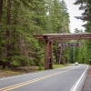
Fryingpan Creek Bridge

Narada Falls

Narada Falls

Trail of Shadows

Trail of Shadows

Christine Falls

Nisqually River

Pinnacle Peak

Stevens Canyon Road

Tunnel, Stevens Canyon Road

Stevens Creek

Box Canyon

Box Canyon

Roots of a Giant

Grove of the Patriarchs Trail

Mount Rainier and Louise Lake

Mount Rainier in Reflection Lake

Mount Rainier
credit: Ashlyn G
Tags: Best, canon 6d, Cascade Range, Mount, mount rainier, mount-rainier-national-park, mountainside, National, Nature, outdoors, Panorama, park, photos, Rainier, U.S. National Park Service, washington state
Relevant Articles
The Hakuba alps lies from north to south in direction here with over 2,500 meters and nearly 3,000 meters high above sea level as Mt. Shirouma, Mt. Goryu or Mt. Karamatsu. Mount Karamatsu is just one of Nagano’s many landmarks. It is a 8,845 ft / 2,696 m mountain peak in the Hida-sanmyaku Range in Nagano, Japan. It ranks as the 22nd highest mountain in Nagano and the 50th highest mountain in Japan. The nearest peaks are Goryu, Yariga-take, Kashima Yarigatake, Shirouma-dake, Jiiga-take, and Tsurugi-dake.

Brocken spectre at Happo-ike pond

South side

Happo-ike pond

Happo-ike mirror

Happo-ike pond

Traverse

Mt. Karamatsu-dake

A snowy gorge
credit: hwat
Tags: Dake, Hakuba-mura, happo, happo-ike, Hiking, Japan, Karamatsu, karamatsu Dake, Mount, mt. karamatshu, south side, trail Nagano Prefecture, traverse
Relevant Articles
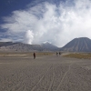
Mount Bromo is a part of the Bromo Tengger Semeru National Park that covers a massive area of 800 square kilometres, located some 4 hours drive from Surabaya, the capital of East Java. Watching the sun rise spectacularly over Mt Bromo is the highlight of any trip here. Mount Bromo which stands tall at 2329 m is one of the most iconic mountain in Indonesia. The most popular way to visit Mount Bromo is to take a roughly 45 minute scenic walk from either of the nearby mountain villages of Cemoro Lawang or Ngadisari. The Tenggerese are the native people, and they reside in quaint, flowered villages scattered in and around the park.

credit: jmhullot

credit: jmhullot

credit: sara marlowe

credit: johan wieland

credit: DamienHR

credit: kamsky

credit: skyseeker

credit: Arian Zwegers

credit: mararie

credit: dany13

credit: michael-day

credit: michael-day
Tags: Bromo, eastern java, Indonesia, java, Magnificent, Mount, mount bator, mount bromo, Volcano, Vulcano
Relevant Articles
Everest is the highest mountain in the world, 29,035 feet (8,850m) above sea level. Mount Everest are still growing higher, at a rate of about 2.4 in (6.1cm) per year, couse the Indian Tectonic Plate slides north under the Eurasian Plate. It is located on the border of Nepal and Tibet. In July, temperatures can get as high as nearly zero degrees Fahrenheit (about -18 Celsius). In January, temperatures drop to as low as -76°F (-60°C).
The approximate elevations of the camps:
Base Camp – 17,500ft (5,400m)
Camp 1 – 20,000ft (6,100m)
Camp 2 – 21,300ft (6,500m)
Camp 3 – 24,000ft (7,400m)
Camp 4 – 26,000ft (8,000m)
Summit – 29,035ft (8,850)


credit: Sistak
Tags: Basecamp, Chomolungma, Everest, Everst Base Camp, Highest, Highest Mountain, Himalayas, Kathmandu, Mount, mount everest, mount everest facts, mountain, mt everest climb, mt everest expeditions, mt everest height, mt everest pics, mt everest pictures, Mt. Everest, Nepal, Qomolangma, tallest mountain, Tibet, world
Relevant Articles
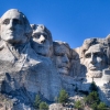
Mount Rushmore is located in the Black Hills of South Dakota. Doane Robinsons idea was to create an attraction that would draw people from all over the country to this state. He is known as the Father of Mount Rushmore. The Mt Rushmore memorial was created by master sculpture Gutzon Borlgum with the assistance of over 400 blasters, carvers and workers. Construction of the granite rock faced mountain began in 1927 when Borglum was 60 and the sculptures of the Mount Rushmore presidents were not completed until Borlgum’s death in 1941. Creation of the Shrine of Democracy took 14 years and cost a mere $1 million. Each head on Mt. Rushmore is as tall as a six-story building. The presidents noses are 20 feet long, each mouth 18 feet wide and the eyes are 11 feet across. The four presidents carved in the mountain are George Washington, Thomas Jefferson, Theodore Roosevelt and Abraham Lincoln. At first, there was a suggestion to carve famous western figures, people like Buffalo Bill, Lewis & Clark, and Sacagawea. But a special group, a commission, instead chose these presidents because they best represented the foundation, expansion and preservation of the United States.


credit: Sebastian Bergmann
Tags: about, crazy horse monument, facts, Memorial, Mount, mount rushmor, mount rushmore, mount rushmore faces, mount rushmore facts, mount rushmore location, mount rushmore lodging, mount rushmore national park, National, national memorial, president mountain, presidents mount rushmore, Rushmore, where is mount rushmore located, who built mount rushmore
Relevant Articles
Kilimanjaro is this the highest peak on the African continent. It is located in Northeast Tanzania, near the Kenya border. It is one of the world’s most accessible high summits for visitors around the world. Kilimanjaro is a volcano. Kilimanjaro consits of three distinct volcanic cones: Kibo 19,340 feet (5,895 meters), Mawenzi 16,896 feet (5,149 meters) and Shira 13,000 feet (3,962 meters). Kilimanjaro has 2.2 square kilometers of glacial ice and is losing it quickly due to global warming. Climbing Kilimanjaro is easy and requires no experience with climbing. You should only take care from improper acclimatization and altitude sickness.


Tags: africa, climbing kilimanjaro, hike kilimanjaro, hotels tanzania, ilimanjaro's summit crater, in tanzania, Kibo, kili, Kilimanjaro, Kilimanjaro Peak, known as Kibo, measures 1.5 miles across. The highest point on Kibo's steep rim is Uhuru, Mount, mount kilimanjaro, mountain, mt kilimanjaro, Nature, Nature, Roof, safari, tansania, tanzania, tanzania africa, tour tanzania, wild africa
Relevant Articles
 Scenic Glacier National Park, Mo...
 Facts about Mount Rushmore Natio...
 Joshua Tree National Park Photos
 Aurora over Denali National Park...
 BushWalking Across Kakadu Nation...
 Great Pictures of Yellowstone Na...
 The Magnificent Mount Bromo Volc...
 Zhangjiajie – National For...
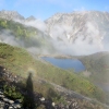
 Mount Kilimanjaro – The Ro...
 Mount Everest – Highest Mo...
 Best Skiing Holiday in Austrian ...
 Best Photos of Mount Rainier Nat...
 Amazing Ashikaga Flower Park, Ja...
 Etna Volcano Eruption 2011
 Spectacular Grand Teton National...
 Best Photos of Zion National Par...
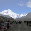
 Hiking Mount Karamatsu Dake, Jap...
 Nepal – One of the Most In...
 Magnificent Mulanje Mountain and...
 Stelvio Pass Breathtaking Road
 Macro Photography – Flying...
 The Memorial Amphitheater at Arl...
 Top Facts about Amazon Rainfores...
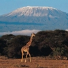
 Drakensberg Park – South A...
 Worlds Highest Bungy from 216 m ...
 Devils Tower National Monument i...


